Post-Padma Bridge Vision: An Eco-Economic Framework from Kumarbhog to Louhajang

Idea projektu
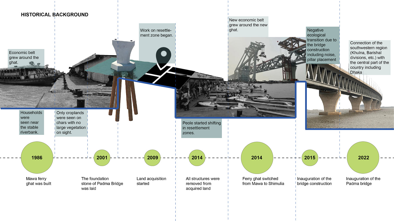
The idea of this project is to develop an adaptive riverine framework that responds to the dynamic environmental and socio-economic challenges of post–Padma Bridge Bangladesh. The project is driven by the increasing problem of riverbank erosion and the resulting loss of land, livelihoods, and settlement stability. At the same time, the shift in movement patterns after the Padma Bridge has led to economic decline in traditional ferry-based communities, disrupting local trade and income sources.
In response, the project aims to reduce these vulnerabilities by transforming environmental challenges into opportunities for resilience. Instead of resisting natural forces such as flooding, erosion, and sedimentation, the design embraces them as active generators of form and strategy. The goal is to create a balanced riverfront where ecological systems, local economies, and community life coexist, ultimately restoring economic vitality while strengthening environmental resilience and cultural continuity.
Popis projektu
A Dialogue Between River Economy and Community
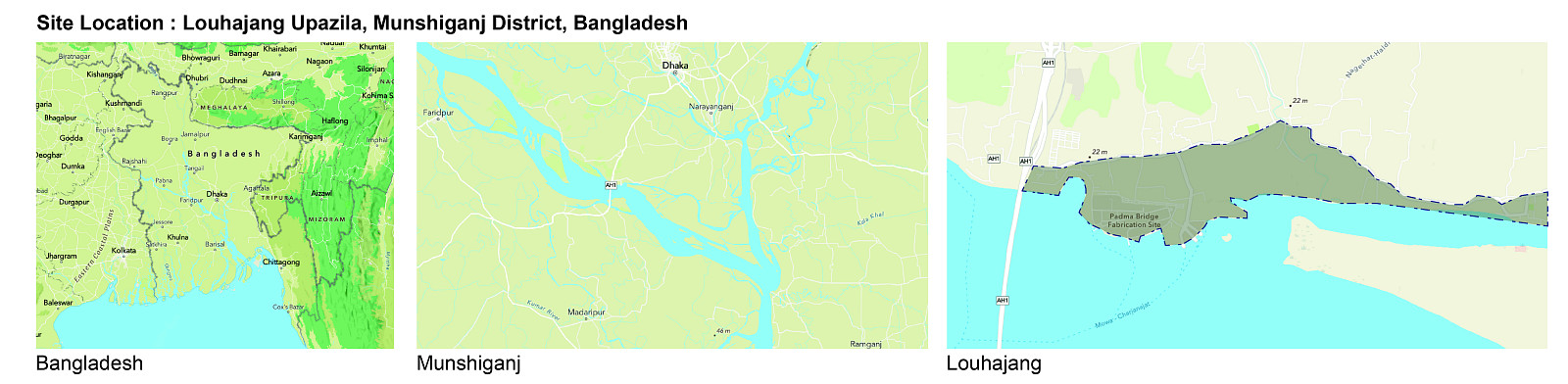
Situated along the dynamic edge of the Padma River, the project explores an adaptive framework for riverine development in post Padma Bridge Bangladesh. The site is continuously shaped by seasonal flooding, erosion, and sedimentation, where the boundary between land and water remains fluid and constantly shifting.
Instead of resisting these natural forces, the proposal treats them as fundamental drivers of design. It envisions a resilient riverfront where ecological systems, local economies, and cultural practices coexist in a mutually supportive relationship, forming a balanced and responsive environment.
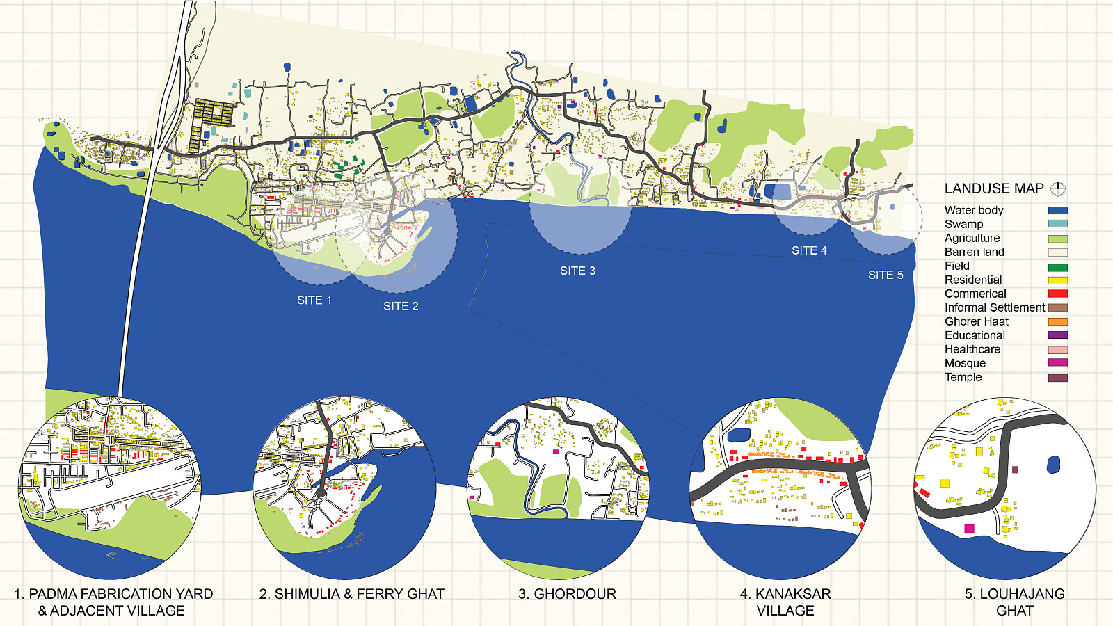
Site Context and Analysis:
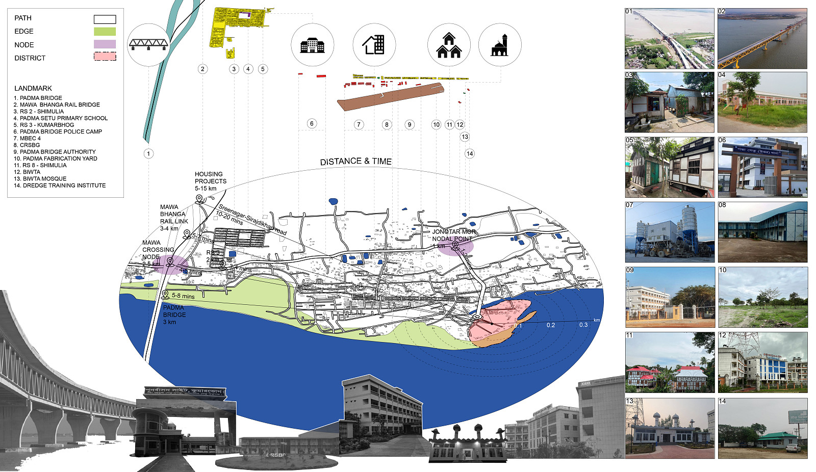
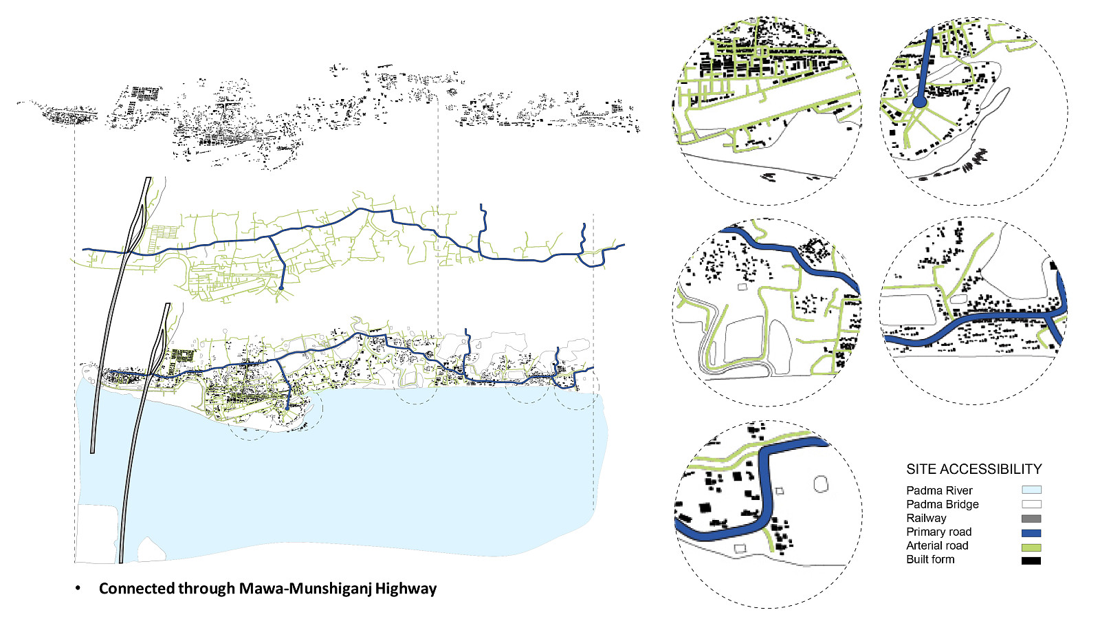
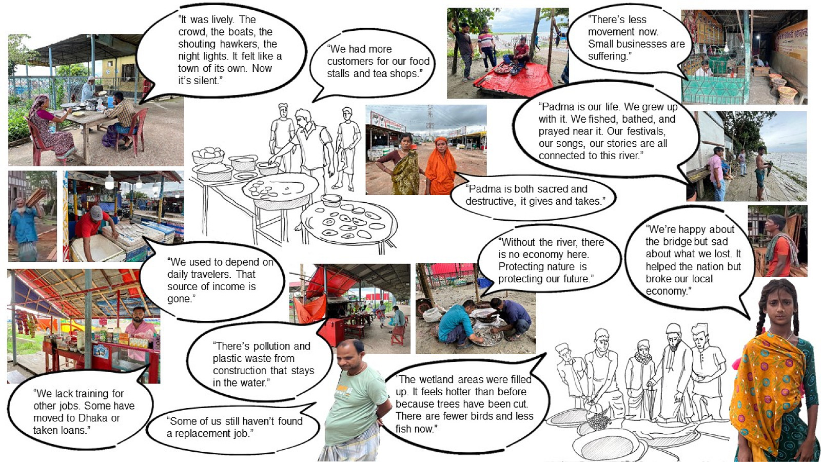
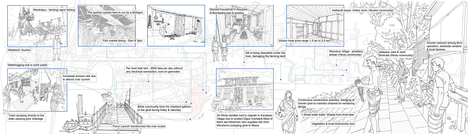
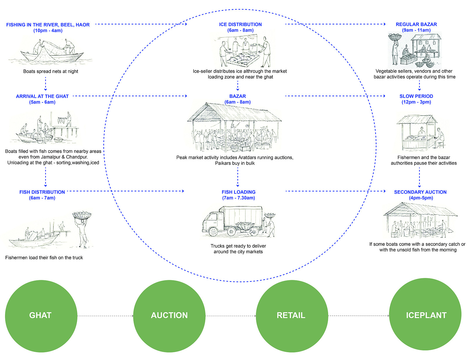
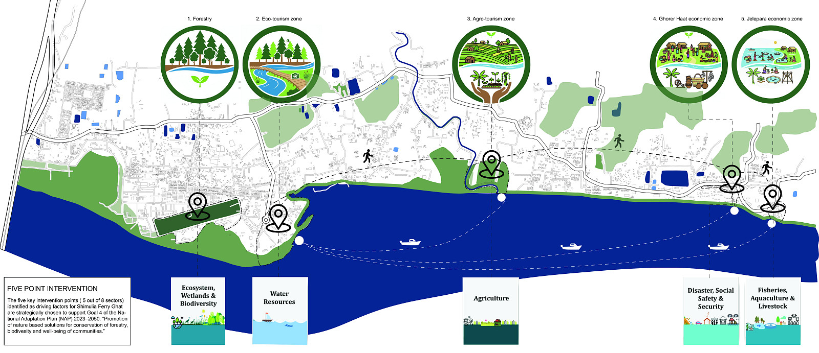
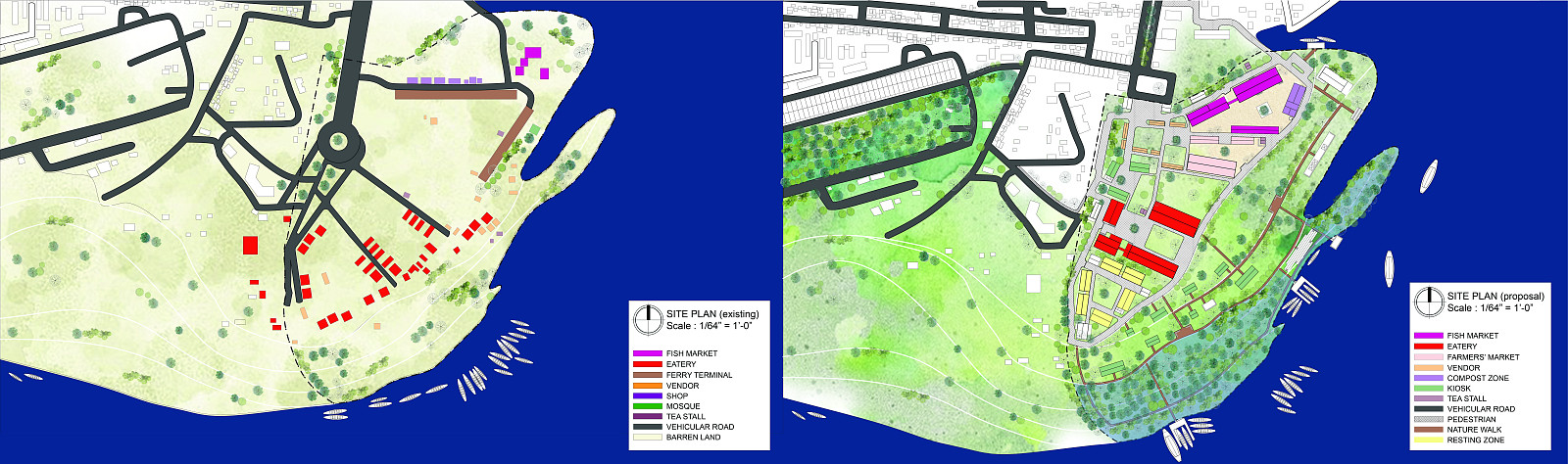
The region is defined by fertile agricultural land, dispersed rural settlements, and active local bazaars. Fishing remains the primary economic activity, closely linked with agriculture and supported by informal trade networks. Ferry ghats and connecting roads act as vital movement corridors, generating periodic intensities of activity across the landscape.
At the same time, the site faces significant environmental challenges. Seasonal flooding, riverbank erosion, and fragmented infrastructure create vulnerability within the community. However, these very processes also sustain soil fertility, aquatic ecosystems, and cultural traditions deeply rooted in the river.
The analysis identifies an opportunity to transform these environmental uncertainties into a framework that supports both ecological resilience and economic stability.
Ecological Strategy and Floodpark Intervention:
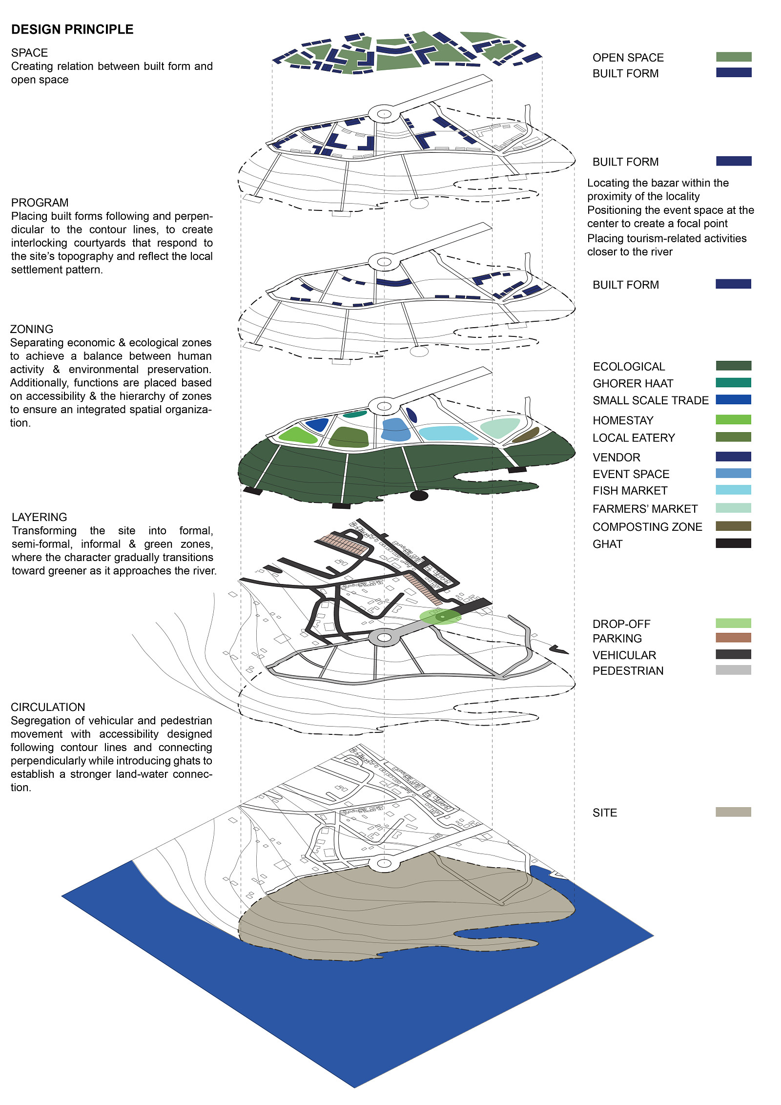
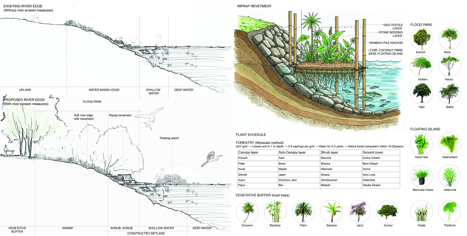
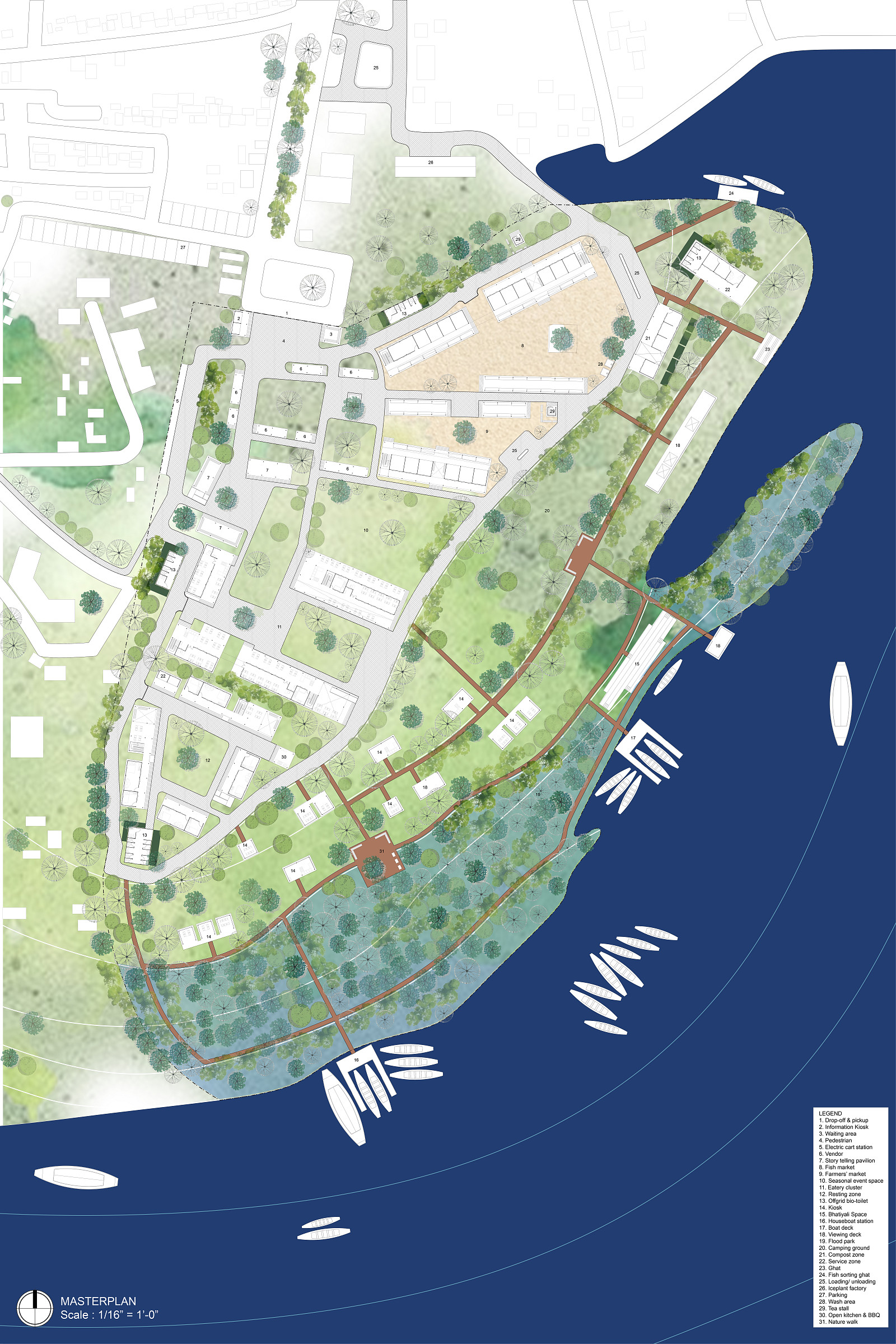
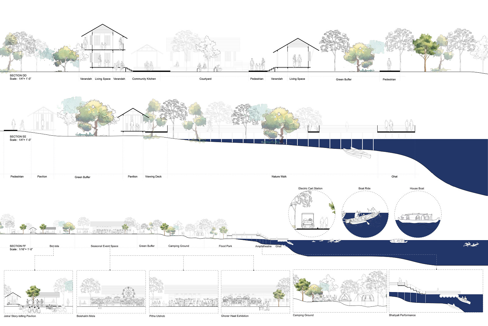
The masterplan dedicates half of the site as an ecological preservation zone that retains natural floodplains and vegetation. This area functions as a flexible landscape capable of accommodating seasonal water fluctuations without disrupting ecological balance.
A floodpark integrated with riprap revetment stabilizes the river edge while allowing controlled flooding during monsoon seasons. This reduces erosion and protects the surrounding land. During dry periods, the same space becomes accessible for public use, encouraging interaction between the community and the landscape.
This approach redefines infrastructure as an adaptive system that evolves with the river rather than opposing it.
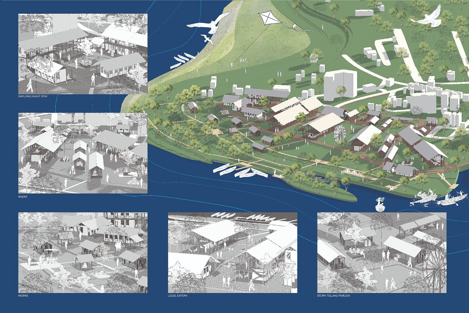
Programmatic Development and Livelihood Support:
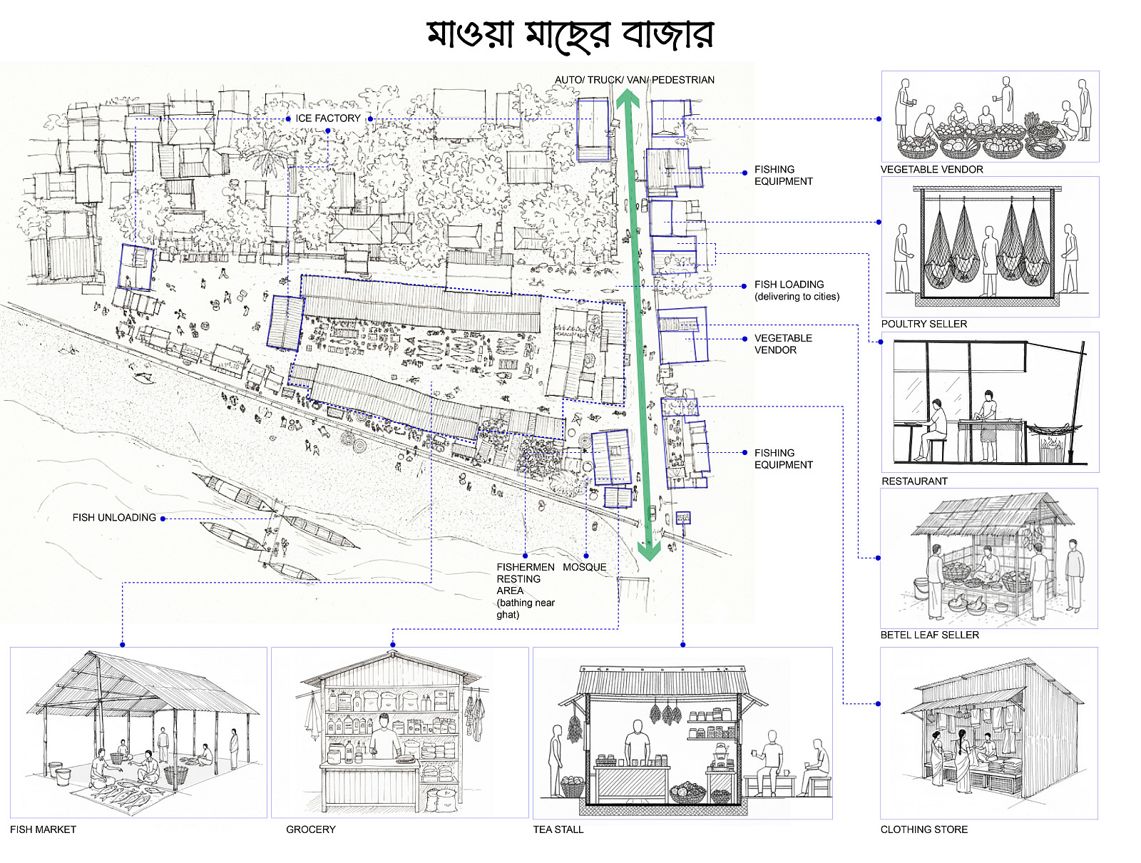
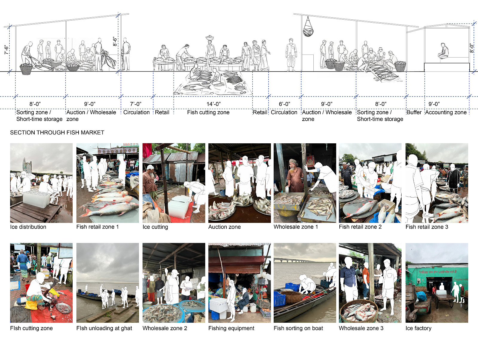
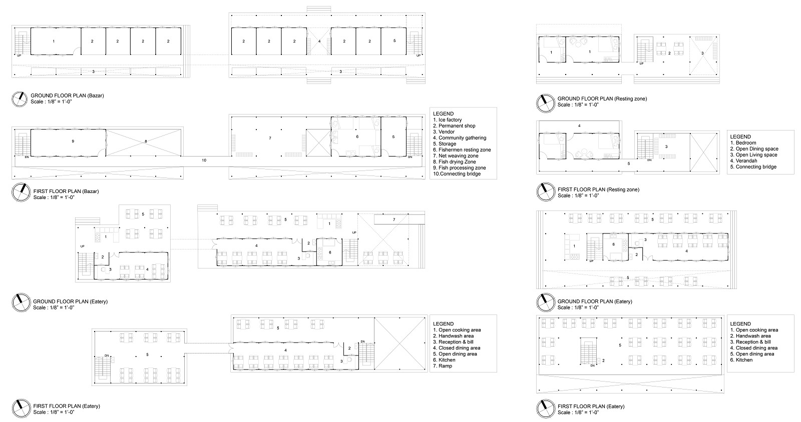
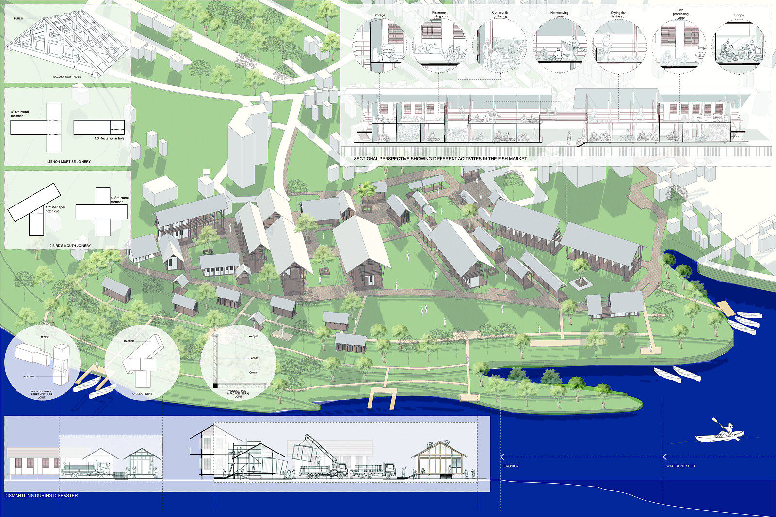
The program emerges directly from existing livelihood patterns. The proposal introduces a fish market, a farmers market, and an ice plant factory to strengthen the economic backbone of fishing and agriculture. These facilities enhance production, storage, and distribution systems that are essential to the local economy.
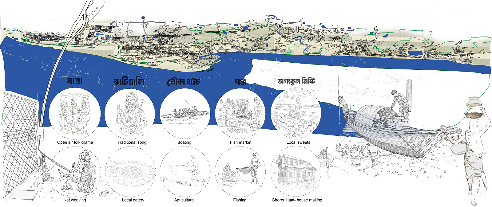
Supporting functions such as composting areas, small vendor spaces, local eateries, and resting clusters for visitors create additional income opportunities while fostering social exchange. Cultural life is integrated through spaces designed for seasonal events such as Boishakhi mela, pitha utshob, and Ghorer Haat exhibitions.
The project also accommodates everyday cultural practices including Bhatiyali performances, storytelling, net weaving, and dry fish processing, ensuring that intangible heritage remains active within the built environment. Essential infrastructure such as bio toilets, pedestrian pathways, electric cart systems, and designated drop off areas ensures accessibility and environmental responsibility across the site.
Climatic Responsiveness:
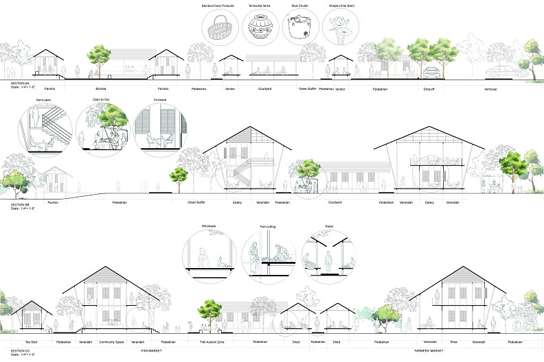
Climatic considerations are integrated throughout the design. Adjustable louvered openings facilitate cross ventilation and reduce glare, while extended roof overhangs protect against intense sunlight and heavy rainfall. A double loaded verandah system acts as a transitional buffer space that minimizes heat gain and encourages shaded social interaction.
Spatial Organization:
The spatial configuration reflects the character of traditional rural settlements. Built forms are organized through a sequence of enclosed, semi open, and open to sky spaces. Tree canopies provide shade and create microclimates, while central courtyards promote ventilation and social connectivity.
Each structure maintains a strong visual and physical relationship with the river, reinforcing the collective identity of the community. The layout allows gradual transitions between private, semi public, and public spaces while maintaining openness and permeability throughout the site.
Design Methodology and Community Participation:
The project follows a design thinking framework inspired by David Kelley. The process begins with understanding the daily lives of fishermen, farmers, and local vendors. It then identifies key challenges such as erosion, flooding, and economic instability before generating adaptive strategies that integrate ecological resilience with livelihood support.
Although full scale prototyping is beyond the scope of the academic project, flexibility is embedded within the design. Modular structures and adaptable spaces enable users to modify and evolve the environment over time, making the community an active participant in the design process.
The project redefines the riverfront as a living and evolving system rather than a static boundary. It integrates ecological processes with economic activities and cultural practices to create a balanced and resilient environment.
Instead of offering a fixed solution, the proposal establishes a flexible framework that can adapt to environmental changes and community needs over time. It acknowledges uncertainty as a design opportunity and positions adaptability as a central principle.
This is not a final answer but an adaptive solution for the living process of the river by the people.
Technické informace
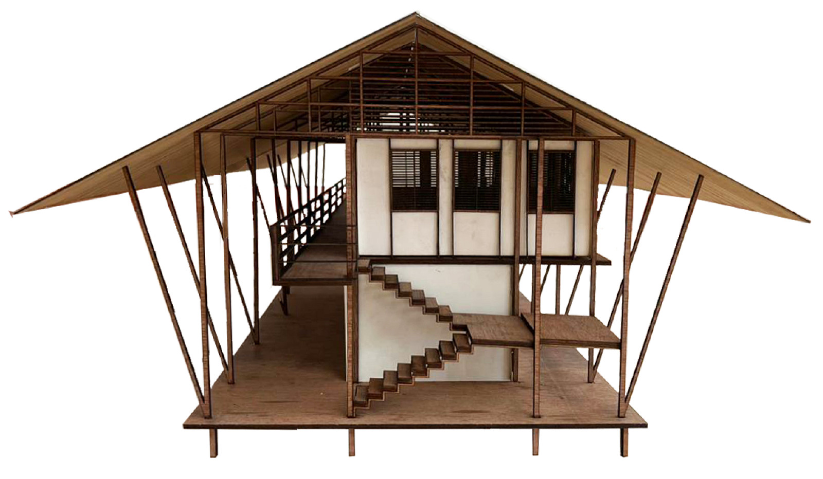
The architectural approach is rooted in local construction traditions, particularly the logic of Kather Bari. A modular system is adopted to allow flexibility and adaptability in response to changing site conditions.
Structures are constructed using mortise and tenon joinery, avoiding metal fasteners and enabling easy assembly and disassembly. The inclusion of a Wagoya roof truss system allows buildings to be relocated if the river shifts over time.
Materials such as treated timber and jute composite tin sheets are selected for their local availability, lightweight nature, and durability in monsoon climates. The use of jute composite introduces a sustainable material innovation grounded in regional resources.
Dokumentace
Copyright © 2026 INSPIRELI | All rights reserved. Use of this website signifies your agreement to the Terms of Use, Privacy Policy, and use of cookies.