Comprehensive landscape improvement of Aiteke Bi Street in Astana incorporating elements of a green-blue infrastructure network

Project idea
The project is a comprehensive improvement of Aiteke bi Street in Astana (Kazakhstan) with the formation of elements of a green-blue framework. The street is located in the Nura district – on the site of the historic connection between the Taldykol lake system and the Yesil (Ishim) River. Due to intensive urban development, this connection was lost, the lakes almost disappeared, and the street turned into a typical transit arterial road with an underdeveloped boulevard.
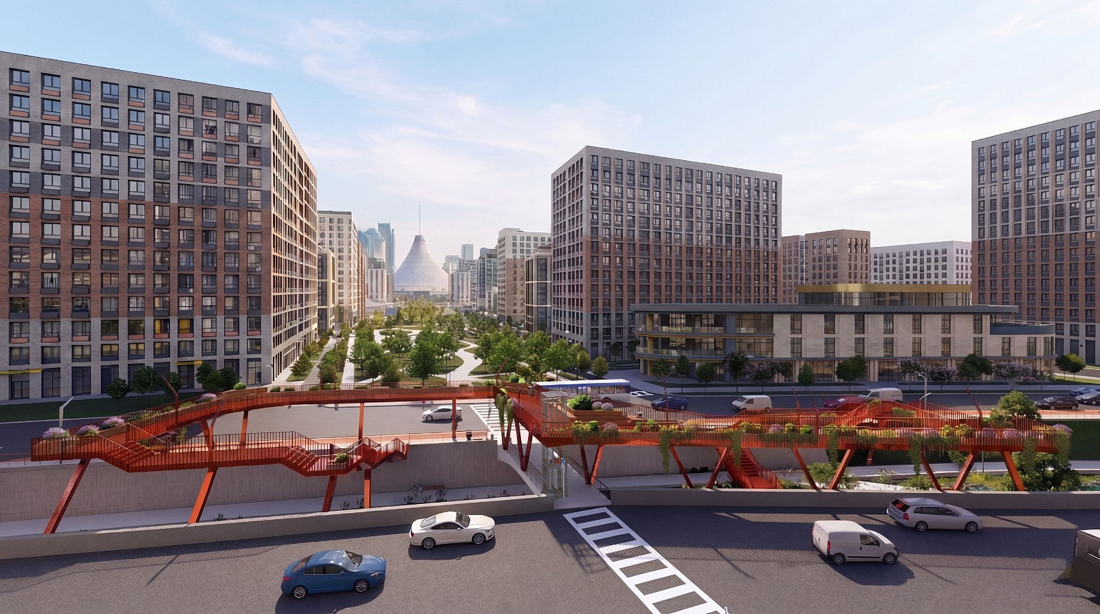
The project’s core idea is to restore the water connection through an open canal running along the entire street and to transform it from a transport corridor into a green-blue artery of the city. The “Flow of Life” concept unites four key nodes corresponding to the existing social infrastructure: a meditative space near the mosque, a gastro zone by the restaurant, a viewing platform at Green Line Park overlooking Khan Shatyr, and an educational cluster near the school.
Design solutions include deepening the central boulevard by 4 m, creating two pedestrian levels (upper – fast transit with bike lanes, lower – promenade zone along the water), a 1 m deep water channel, underground retention reservoirs for meltwater, gravel‑sand filters, and pumping stations connecting the channel to the river and lakes. Climate adaptation ensures stable winter operation (deepening below the freezing zone, passive protection from de‑icing reagents). A selection of salt‑ and drought‑tolerant plants is integrated into the biological water treatment system (bioplato, rain gardens). The project aligns with Astana’s development strategy until 2030, returning the street to people, restoring ecological balance, and creating a new quality of urban environment.
Project description
The project covers a 1.2 km stretch of Aiteke bi Street in the Nura district of Astana. Its key solutions include:
Street profile transformation – deepening of the central boulevard, creation of two pedestrian levels (upper – fast transit with bike lanes, lower – promenade zone along the water) with stairs, ramps, and a lift for people with reduced mobility.
Blue‑green infrastructure – an open water channel along the entire boulevard, underground retention reservoirs and gravel‑sand filters for meltwater management, pumping stations connecting the channel to the Ishim River and Taldykol lakes, as well as bioplato and rain gardens with phytoremediation plants.
Four public nodes:
meditative space near the mosque (octagonal platform with a fountain, aromatic garden);
gastro zone near the restaurant (built‑in kiosks, a wavy wooden terrace by the water, mesh canopy);
viewing platform at Green Line Park (shaped as a Kazakh ornament, glass lift, view of Khan Shatyr);
educational cluster near the school (five sub‑zones: water interaction, parents’ rest area, shallow pool, educational boards, dry playground).
Climate adaptation – stable winter water level due to deepening below the freezing zone, passive protection from de‑icing reagents via runoff interception, summer cooling through evaporation and greenery, wind‑protective green buffers, and materials resistant to temperature extremes.
Plant selection – salt‑ and drought‑tolerant species for slope reinforcement, bioplato, and rain gardens, as well as thematic planting for each of the four nodes (aromatic herbs near the mosque, container plants near the restaurant, vines and trailing plants on the viewing platform, safe and bright plants near the school).
The design solution is presented at a conceptual level sufficient to demonstrate architectural, planning, and ecological principles and can serve as a basis for subsequent development of working documentation.
Technical information
1. General site parameters
Street length: 1.2 km
Central boulevard width: 19–25 m (variable)
Total design area (including sidewalks, bike lanes, boulevard): approx. 4.2 ha
2. Main structural elements
Boulevard deepening below road level: 4 m
Open water channel: depth 1 m, variable width (1 to 4 m depending on zone)
Slope angle of recess embankments: 60°
Two pedestrian levels:
Upper level (sidewalks + bike lanes): sidewalk width 2.5 m, bike lane width 2 m
Lower level (promenade along the water): width 3 to 6 m
Underground meltwater retention reservoirs: total volume approx. 70,000–100,000 m³ (under road and sidewalks)
Pumping stations: 2 units (head and tail)
3. Accessibility
Ramps for people with reduced mobility: at each of the 4 key nodes
Glass lift: 1 unit (at the viewing platform)
Pedestrian bridges over the canal: 6 units (with stairs)
Underground pedestrian crossings under intersecting streets: 3 units
4. Drainage and treatment system (SuDS)
Surface water intake grates: along the entire boulevard at ground level
Underground gravel‑sand filters: integrated into retention reservoirs
Bioplato (reed beds / filter plants): along the canal, total area ~1200 m²
Rain gardens on slopes: total area ~800 m²
5. Landscaping
Total green area: ~1.5 ha
Number of trees planted: ~400
Number of shrubs planted: ~2000
Grass cover on slopes and lawns: ~1.0 ha
Aquatic plants (bioplato): ~1200 m²
6. Materials and surfaces
Sidewalks and pedestrian zones: granite and porcelain stoneware tiles with textured anti‑slip surface
Bike lanes: coloured asphalt concrete
Lower promenade zone along the water: wooden decking (larch) and gravel surfaces
Retaining walls and bridges: reinforced concrete with hydrophobic impregnation (F300‑F400)
Metal elements (railings, canopy supports, viewing platform frame): Corten steel / powder‑coated aluminium
Mesh canopy over the gastro zone: translucent PVC mesh on a metal frame
7. Climate adaptation
Channel depth below 2.4 m (below the soil freezing zone) – passive freeze protection
Cable heating of pedestrian bridges, stairs, lift approaches: ~300 m²
Misting systems for summer cooling: 3 units (near the restaurant, school, and viewing platform)
Drip irrigation system for plants (using treated water from the channel): length ~1.2 km
8. Lighting
Decorative channel lighting: LED strips embedded in ice / under water, shore‑mounted projectors
Functional lighting of upper and lower levels: LED poles 6–8 m high (upper level), low bollards (lower level)
Architectural lighting of nodes (viewing platform, mosque pavilion, mesh canopy)
Documentation
Copyright © 2026 INSPIRELI | All rights reserved. Use of this website signifies your agreement to the Terms of Use, Privacy Policy, and use of cookies.