Relieffold

Project idea
A site analysis and urban design proposal for a 22,063 m2 site in the Nilüfer district of Bursa, Turkey, addressing public use, event-culture, residential, education, healthcare, and commercial/food & beverage functions within a neighborhood-scale gathering and temporary shelter point.
Project description
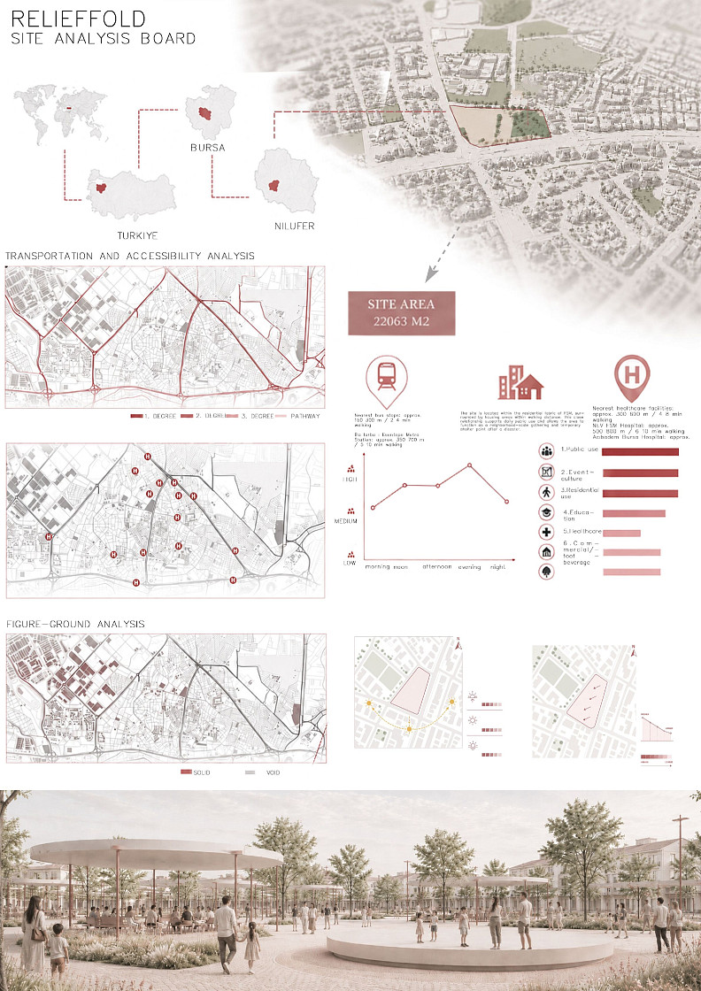
The project presents a comprehensive site analysis board for a urban intervention in Nilüfer, Bursa, Turkey. The analysis covers transportation and accessibility, examining road hierarchies (1st, 2nd, 3rd degree roads and pathways), proximity to public transit including bus stops (150-300m / 2-4 min walking) and the Bursa Esentepe Metro Station (approx. 350-700m / 5-10 min walking), and nearby healthcare facilities (300-600m / 4-8 min walking). The site is located within a residential fabric surrounded by housing areas within walking distance, supporting daily public use and serving as a neighborhood-scale gathering and temporary shelter point after disasters. A program distribution chart shows public use as the dominant function, followed by event-culture, residential use, education, healthcare, and commercial/food & beverage. Pedestrian activity analysis indicates medium-to-high usage throughout the day.
Technical information
Site area: 22,063 m2. Figure-ground analysis shows the solid-void relationship of the urban fabric. Transportation network analysis categorizes roads into 1st, 2nd, and 3rd degree classifications with pedestrian pathways. The site is serviced by nearby bus stops at 150-300m distance and the Bursa Esentepe Metro Station at approximately 350-700m. Nearest healthcare facilities include NEV FSM Hospital at approximately 500-800m and Acıbadem Bursa Hospital.
Documentation
Created in:
Copyright © 2026 INSPIRELI | All rights reserved. Use of this website signifies your agreement to the Terms of Use, Privacy Policy, and use of cookies.