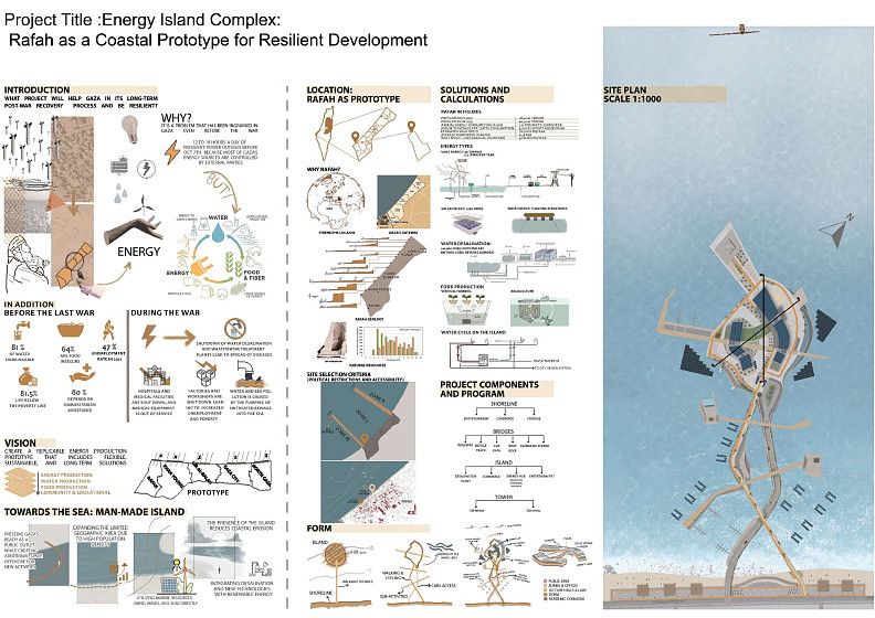
Energy Island Complex: Rafah as a Coastal Prototype for Resilient Development

Project idea
The project aims to develop a comprehensive architectural and developmental vision for the reconstruction of Gaza after the war, beginning with Rafah City as a pilot model for sustainable coastal development.
It represents an integrated experiment that seeks to transform the concept of energy from a mere technical source into a human and developmental infrastructure capable of leading recovery and strengthening the resilience of the Palestinian community in the face of war, climate change, and resource scarcity.
Concept of the Project
The idea emerged from a fundamental question raised while reflecting on the future of Gaza’s reconstruction after the recent war:
“What type of project could truly help Gaza recover in the long term and make it more resilient and self-sufficient?”
The answer was energy.
The energy crisis in Gaza is not a recent phenomenon but a chronic condition affecting all aspects of life — water, food, health, industry, and education.
From this need, the Energy Island project was conceived as an architectural approach integrating energy production, water desalination, food production, scientific research, and community interaction within a single cohesive spatial framework — one that reconnects humans with their environment and redefines the relationship between architecture and nature.
Project Objectives
The project seeks to present a new urban and economic model based on the integration of productive infrastructure with social, educational, and recreational functions, creating a platform that is at once educational, economic, and touristic.
It reinforces the concept of genuine sustainability through:
• Production of renewable energy (wind, solar, and wave energy).
• Seawater desalination powered by clean energy to provide fresh water for daily use and agriculture.
• Development of sustainable food systems (vertical farming and aquaculture).
• Recycling of war rubble and local materials to produce building elements and façades.
• Creation of open public spaces and educational and research facilities serving the local community.
Project description
Site and Urban Context
Rafah, located at the southernmost tip of the Gaza Strip, was selected as the pilot site for its unique geographic position on the Mediterranean Sea and its role as Gaza’s gateway to the world through its border with Egypt.
Rafah’s site offers ideal environmental conditions for renewable energy generation, recording the highest wind speeds and solar radiation levels in the Gaza Strip — making it the perfect testing ground for a replicable model along the Palestinian coast.
The project also responds to Gaza’s urban challenges — limited land, high population density, and coastal erosion — by extending development into the sea, creating a new artificial island that preserves the shoreline as a public open space while expanding the city’s footprint without encroaching on existing residential zones.
Environmental Rationale for the Marine Site
The decision to implement the project offshore(artificial island), near the Rafah coastline, stems from intertwined urban, ecological, and social reasons:
1. Preserving the beach as a public open space and natural breathing zone for Gaza’s residents.
2. Expanding Rafah’s limited geography by introducing a new marine-based urban cluster, allowing new economic and touristic opportunities.
3. Utilizing marine resources — wind, wave, and solar energy — for clean power generation.
4. Protecting the coastline from erosion, as the island acts as a natural wave breaker and stabilizer of the shore.
5. Preserving bird migration routes, with wind turbines strategically positioned outside migratory corridors to ensure ecological balance.
6. Enhancing marine biodiversity, as the island’s structural system functions as an artificial reef, attracting fish and marine species and regenerating the ecosystem damaged by pollution and war.
Design Vision
The project’s design vision is founded on the principle of transformation — from destruction to hope, from debris to reconstruction.
The overall form is inspired by wave movements, ensuring full harmony with the coastal environment.
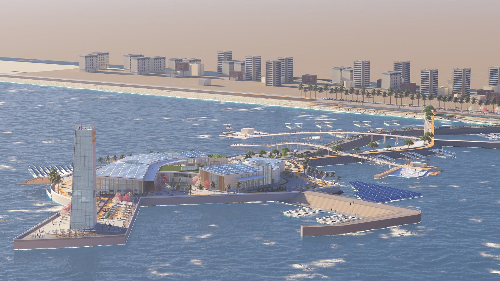
The urban sequence begins at the shoreline, which hosts recreational spaces, cafés, and bike paths, continuing to the interactive bridge that connects the mainland and the island — a dual route for pedestrians, cyclists, vehicles, and marine activities — leading finally to a central plaza that acts as the social heart of the development.
Around this plaza stands the Energy Hub, a multifunctional complex encompassing a public market, library, workshops, laboratories, and housing for students and researchers.
The building incorporates a series of vertical courtyards designed to:
• Bring natural light deep into the building core.
• Enable cross-ventilation between floors.
• Integrate vertical farming as a productive, educational, and aesthetic element.
• Connect horizontal levels through dynamic vertical interaction.
Bridge Surroundings and Marine Activities
In addition to fish farming networks shaded by solar panels and distributed around the bridge,
floating structures have been added on both sides of the bridge, hosting swimming and kayaking activities.
The enclosed area between the two bridge sections has been designed as a safe water zone for children and youth boating, creating an interactive and educational marine environment.
Energy Hub – Functional Layout
Ground Floor – Public and Community Space
This is the most open and interactive level, designed to make energy a tangible and educational daily experience.
It includes:
• An indoor public market selling island-produced goods (fish, crops, local products).
• A public library.
• Community workshops.
• Multipurpose halls for lectures, exhibitions, and community events.
• A sea-view restaurant and café overlooking the plaza, using locally produced ingredients.
The ground floor opens visually to the central plaza, offering shaded walkways, natural ventilation, and varying sea views.
First Floor – Educational and Research Zone
This level serves as the academic and research core, comprising:
• Scientific laboratories for renewable energy, desalination, and aquaculture.
• Lecture halls for students in sustainable energy and environmental design.
• Administrative and academic offices.
• Training spaces for solar and wind system maintenance.
• Open corridors overlooking courtyards with vertical farming systems.
It creates a self-sufficient academic community, integrating living, research, and work.
Second Floor – Residential and Technical Services
This floor includes two main blocks:
• Block 1: Residences for researchers, students, and staff, featuring private and shared units with sea-view lounges.
• Block 2: Advanced laboratories, control rooms for energy and desalination systems, and mechanical maintenance areas.
The level connects to rooftop terraces covered with solar panels, serving as observation decks for educational tours.
Basement – Desalination and Technical Operations
• Main desalination plant with a capacity of 120,000 m³/day.
• Pumping and storage rooms connected to the island’s water cycle system.
• Greywater and blackwater treatment units for reuse in irrigation.
• Electrical systems and backup generators.
• Maintenance corridors and observation spaces for educational tours of the desalination process.
The Tower
Rising at the end of the island, the tower serves as a symbol of hope and resilience.
It houses vertical farms, a panoramic restaurant, and a renewable energy observation deck — a beacon of light and aspiration, visible from Rafah’s shore and beyond.
Technical information
The proposed Energy Island covers approximately 30 km², , sized to support the desired Desalinated water production capacity, and is located within walking distance ( 385 meters) from the shoreline in water depths of less than 10 meters. The project features 40 wind turbines, over 500 solar panels, and wave energy systems, generating approximately 0.7 TWh of electricity annually, enough to supply about 60% of Rafah’s projected energy demand by 2035. It also includes a reverse osmosis desalination plant capable of producing approximately 120,000 m³ of fresh water per day, powered entirely by renewable energy.
Energy Hub Façades
Southwestern Façade
This façade is the most sun-exposed and is treated with mashrabiyas made from recycled war rubble, symbolizing resilience while serving an environmental purpose.
The mashrabiyas filter sunlight and reduce solar gain while maintaining visibility and natural light.
They significantly lower interior heat through permanent shading and enhanced airflow.
Northern and Eastern Façades
These façades use sandblasted louvers and panels crafted from locally sourced Gaza beach sand, ideal for the humid marine climate.
The rough texture prevents glare and dirt accumulation.
Additionally, locally produced bricks made from local materials were used to enhance sustainability and local identity.
Structural System
The project employs an advanced marine structural system based on the Caisson Foundation, commonly used for heavy offshore construction.
Key features include:
• Caisson units built onshore using reinforced concrete molds, and transported to sea to rest firmly on the seabed, later filled with rubble and sand, forming the island’s foundation.
• A Raft Slab built atop these caissons, supporting columns and utility networks.
• Use of locally recycled materials from war rubble, symbolizing reconstruction through renewal.
• Integration with the marine ecosystem, allowing algae and aquatic organisms to grow on submerged surfaces, forming a supportive underwater habitat.
• Acting as natural wave breakers, the structures reduce current intensity and create new breeding grounds for fish.
Water Cycle System
The island operates through a closed-loop water cycle, ensuring efficient resource use and recycling:
1. Desalination: Seawater is processed through reverse osmosis, producing 120,000 m³/day.
2. Distribution: Desalinated water supplies residents, vertical farms, and fish farming systems.
3. Collection: Greywater and blackwater from buildings are collected for treatment.
4. Greywater treatment: Reused for irrigation and vertical farming.
5. Blackwater treatment: Undergoes biological and mechanical purification before safe reuse or discharge.
6. Excess desalinated water: Used for cooling wind turbines and recreational marine activities around the island.
Documentation

Copyright © 2026 INSPIRELI | All rights reserved. Use of this website signifies your agreement to the Terms of Use, Privacy Policy, and use of cookies.