Nile Wheat Nexus


Project idea
Egypt is the world's largest importer of wheat, yet loses an estimated 15–20% of its own harvest between the field and the table. This is not, in the first instance, an agronomic failure — it is a failure of translation. The evidence to grow, store, and process wheat better already exists; what is missing is the system that reliably converts that evidence into practice on farms, in silos, in mills, and in bakeries.
The Nile Wheat Nexus treats this missing system as an architectural problem. The idea is a building that is itself a pipeline: a national verification-and-transfer engine that receives real wheat problems from the field, diagnoses them through research, validates the solutions at pilot scale, and returns protocols, standards, and trained operators back to the country. The goal is to demonstrate that resilience is not only studied but produced — that an architecture can be organized so precisely around a national problem that the plan and the process become the same thing.
The site sharpens the idea. The campus sits on the active Nile floodplain, where seasonal flooding is treated not as a hazard to resist but as a phenomenon to study — turning the project's greatest site constraint into its central research instrument.
Project description
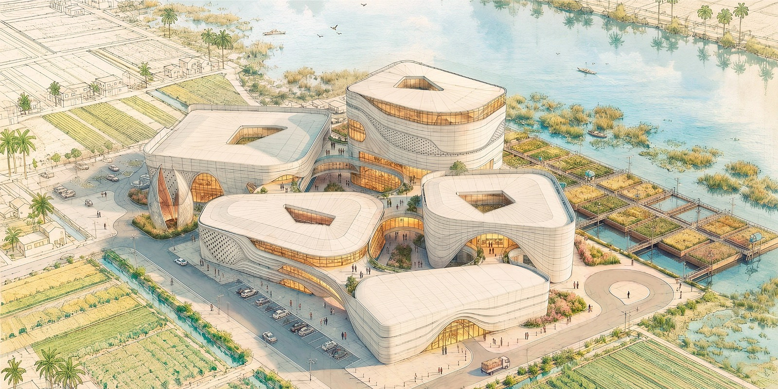
The campus comprises a 40,000 m² gross program across five buildings, organized as a single continuous pipeline from public arrival to applied service. It follows the path of the grain itself — seed to bread — so that the visitor, the researcher, and the sample all move through the same legible sequence.
The program is structured into nine packages across four operational bands. The public interface (Package A) is the civic front door, where real grain samples physically enter the campus and the national stakes are made visible. The convening band (Packages B and E) hosts national wheat summits, policy negotiations, and the training and certification of the operators who deploy verified protocols in the field. The research core (Packages C and F) is the scientific engine: five laboratory clusters covering the full wheat value chain — genetics and agronomy, climate and salinity, post-harvest storage and loss, and milling and bread quality — supported by the policy, economics, and data-intelligence teams who translate research into national decisions. The applied band (Packages D, G, H, and I) holds the pilot mill, test bakery, and demonstration storage that prove research findings at controlled scale, alongside logistics, administration, and building services.
The defining spatial move is the floodplain landscape. The wheat beds surrounding the campus are not a landscape gesture but a working research apparatus, where the seasonal behavior of the floodplain is recorded and studied as data. A strict separation of clean, public, research, and service flows runs through the entire plan, allowing collaboration without contamination or security breach.
Technical information
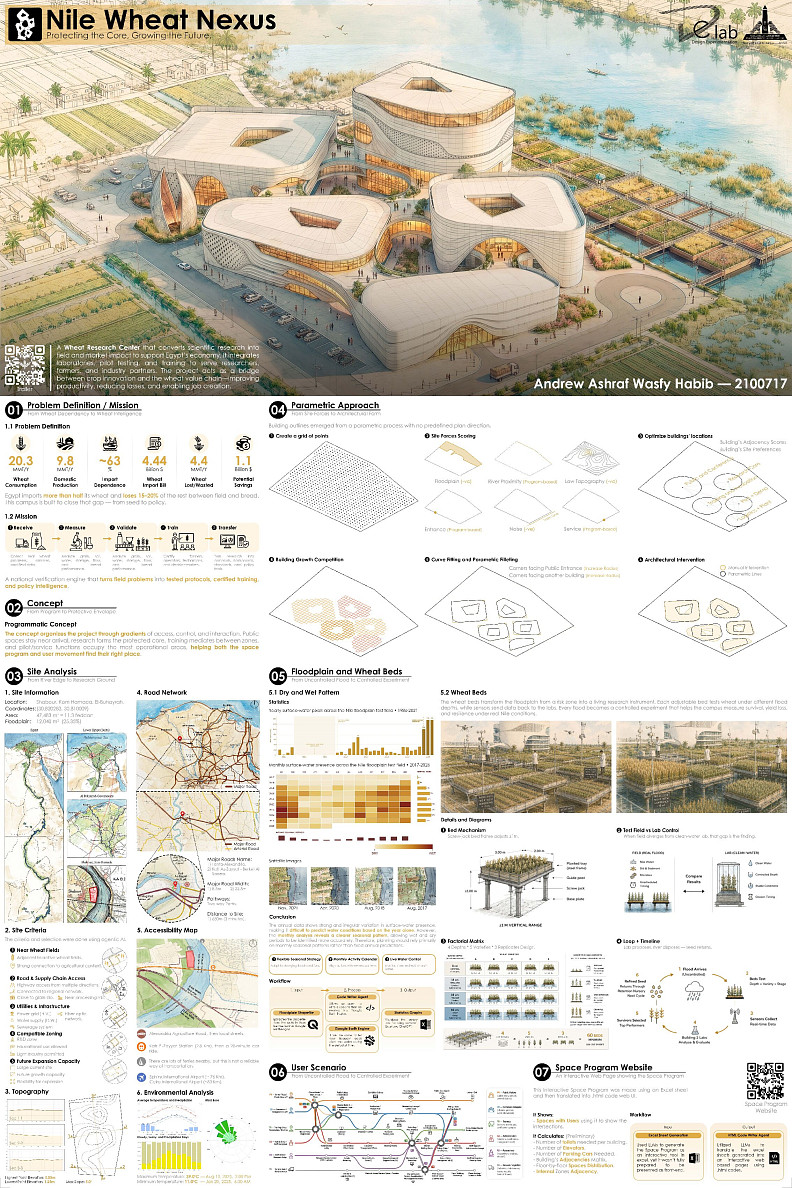
The campus form is computationally generated rather than conventionally composed, using a two-layer parametric system that separates the building mass from its skin. The first layer grows the building masses through a cellular-automata process driven by the forces of the site, executed through a custom C# script (resolving a 4,036-point grid in approximately 82 milliseconds). The second layer modulates the parametric skin independently, driven by environmental data — solar exposure, prevailing wind, and the Nile view — so that every opening, depth, and density on the façade is the trace of a measured condition rather than a stylistic choice. The generative workflow runs in Rhino and Grasshopper, with Wallacei used for evolutionary optimization of package zoning.
A 38-year Google Earth Engine satellite dataset of the floodplain's flood states establishes that flooding here is seasonally patterned but unpredictable in magnitude — the empirical basis for treating the surrounding landscape as an active research instrument rather than a passive site condition.
The building is sized and zoned to a total occupant load of approximately 5,293 persons, with all life-safety, egress, and occupant-load provisions developed against the Egyptian Code 305 and NFPA 101. The 40,000 m² gross program sits on a 31,405 m² site, with a 10,800 m² footprint (34%) distributed over three to four floors, the remainder given to test plots, a flood-adaptive ecological buffer, public plaza, and screened service infrastructure.
Documentation

Copyright © 2026 INSPIRELI | All rights reserved. Use of this website signifies your agreement to the Terms of Use, Privacy Policy, and use of cookies.