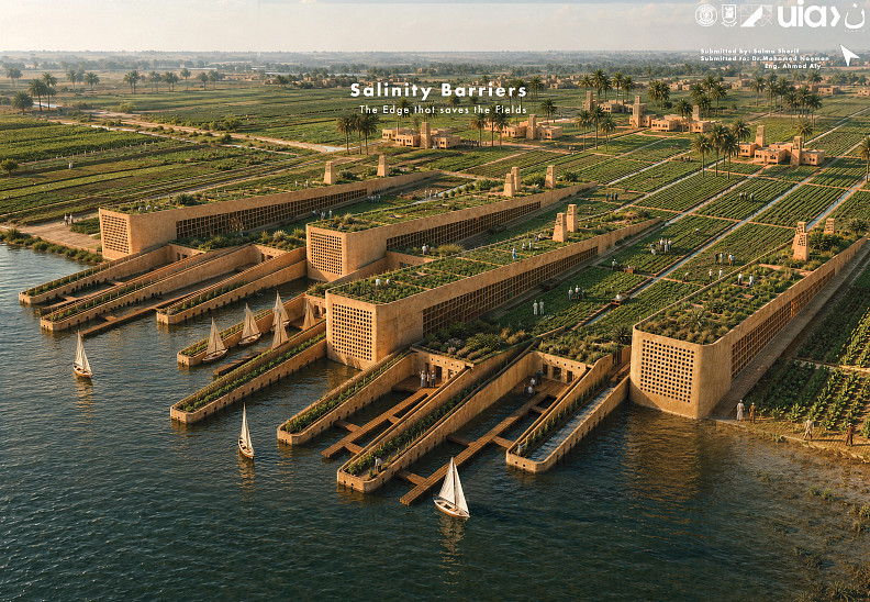
Salinity Barriers
Project idea
Salinity Barriers: The Edge that Saves the Fields is an architectural and ecological intervention for the agricultural edge of Rashid/Rosetta, where cultivated land meets the Nile water system and faces increasing soil salinity, seasonal saline intrusion, land loss, and declining crop productivity. The project redefines the waterfront not as a passive boundary, but as a productive defensive edge: a hybrid system of architecture, filtration landscapes, agricultural roofs, community facilities, and water-management channels. The core idea is to transform the vulnerable river–field interface into a living salinity barrier. Instead of separating architecture from agriculture, the project makes the building itself part of the environmental infrastructure. Long linear buildings are positioned parallel to the agricultural plots and extended toward the water through narrow filtration beds. These “finger” beds receive highly saline water during water-level rise, slow it down, expose it to planted halophyte systems, and then redirect the treated flow into primary and secondary irrigation channels serving inland fields. The project responds to the specific crisis shown in the boards: rising water levels, soil salinity, damaged crops, submerged agricultural lands, and seasonal salinity variation. The proposal therefore does not treat the site as a conventional waterfront development. It acts as a threshold between risk and recovery: water enters, is filtered through planted beds, moves through controlled channels, supports roof and ground agriculture, and is connected to public market and community programmes. The intervention is both protective and productive — defending existing agricultural land while expanding cultivation through inclined agricultural rooftops and organised community farming spaces. Architecturally, the project uses the language of the Egyptian Delta: earthy rammed-earth walls, perforated screens, agricultural roofs, access towers, palm landscapes, water channels, and market spaces. The result is a project that merges infrastructure, ecology, public life, and rural economy into one continuous edge condition.
Project description
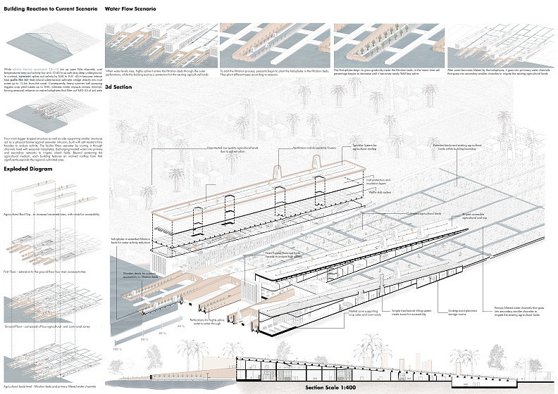
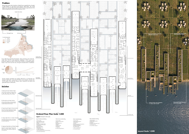
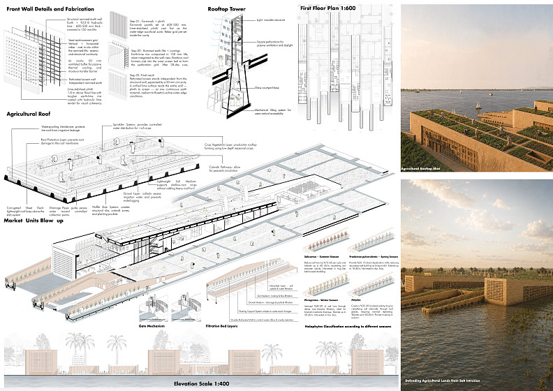
The project is located in the agricultural context of Rashid/Rosetta, within the Nile Delta landscape, where the relationship between water, soil, farming, and settlement is fragile. The boards identify the main problem as the combined impact of rising water levels and soil salinity on agricultural land. The scenario analysis shows land affected by different electrical conductivity levels, including zones below 2 dS/m, 2–4 dS/m, 4–8 dS/m, and above 8 dS/m. These salinity bands become the basis for the architectural and landscape strategy: the more exposed edge receives the first defensive and filtration layers, while inland zones are protected by redirected water channels and cultivated surfaces. The project addresses the seasonal behaviour of salinity. In winter, seawater intrusion is represented as moving around 10–12 km through open Nile channels, while cooler temperatures keep salts deeper underground and soil salinity lower. In summer, the boards show a more critical condition: soil salinity rises significantly, reaching around 9.61 dS/m in the scenario analysis, as heat and groundwater movement pull the saline wedge toward root zones. The project therefore proposes an adaptive seasonal system rather than a fixed wall. It uses halophytes, filtration beds, perforated water-entry zones, primary and secondary canals, and agricultural roofs to manage different levels of salinity throughout the year. The master plan is organised as a series of long, linear built bars extending from the agricultural land toward the Nile. Between these bars, narrow planted filtration beds project into the water. These beds are not decorative water features; they are functional ecological devices. During high water conditions, saline water enters through controlled perforations and is slowed inside the filtration channels. Farmers then plant specific halophyte species according to the season. As the plants grow, the salinity percentage is reduced according to the project’s filtration logic, before the water moves inland into a structured network of primary water channels and smaller secondary canals. The architectural intervention combines several programmes. The ground level includes productive and communal functions such as market units, public community spaces, public workshops, agricultural support areas, storage, and circulation routes. These uses are placed below or beside agricultural surfaces so that the building supports both the local economy and the farming process. The market areas allow crops and products from the reclaimed/agricultural system to be sold directly, while community and workshop spaces support knowledge exchange, maintenance, and collective agricultural activity. Above the programme, the roofs become productive landscapes. The inclined rooftops are designed as agricultural roofs with low-depth seasonal crops, controlled irrigation, sprinklers, drainage layers, catwalks, and vegetation beds. These roofs extend the cultivated area and visually merge the architecture with the surrounding fields. Rather than adding isolated green roofs, the project treats the roof as a continuation of the agricultural ground plane. The project also includes ventilation and accessibility towers. These towers support passive ventilation and daylight, while also acting as vertical circulation and access points. Their form relates to local rural structures and Delta vernacular silhouettes, allowing the technical system to remain visually connected to the site’s cultural landscape.
Technical information
The project responds to measurable salinity and water-level risks at the Rashid/Rosetta agricultural edge. The boards identify nearly **3,500 feddans** of agricultural land lost or severely affected, including around **3,100 feddans** permanently submerged. Soil salinity is mapped by electrical conductivity: * **EC < 2 dS/m:** 21,047.61 feddans * **EC 2–4 dS/m:** 68,778.90 feddans * **EC 4–8 dS/m:** 6,824.06 feddans * **EC > 8 dS/m:** 841.45 feddans This means around **7,700 feddans** are affected by salinity levels above **4 dS/m**, the threshold where many crops begin to suffer. The boards also show crop-yield decline of around **10–12% for wheat** and **13–15% for maize**, with a projected **30% food-production decline by 2030** if no intervention occurs. The seasonal scenario drives the design. In winter, seawater intrusion reaches around **10–12 km** upstream, with soil salinity around **6.10 dS/m**. In summer, salinity rises by about **56%** to approximately **9.61 dS/m**, as the **63 km inland saltwater wedge** moves toward the root zone, affecting areas up to **15 km from the coast** and causing potential crop losses up to **40%**. Technically, the project works as a layered water-treatment edge: **saline water entry → perforated barrier → halophyte filtration beds → primary channels → secondary irrigation canals → protected fields** The filtration beds project into the water as long planted fingers. They slow saline water, expose it to soil, gravel, and halophyte root systems, then redirect it into controlled irrigation channels instead of allowing untreated saline water to enter the fields directly. The diagrams represent a staged salinity-reduction logic from the exposed edge inward, shown as **100% → 90% → 80% → 60%**. The halophyte system is seasonal. **Salicornia** is used for the high-salinity summer condition, with tolerance up to about **50 dS/m**. **Frankenia pulverulenta** is used in spring, with tolerance up to about **18 dS/m**. **Phragmites** supports winter filtration through dense root/rhizome systems, while **Atriplex** supports transitional salinity control and soil stabilisation. The boards state that native halophytes can filter approximately **35–40%** of soil salts within the project scenario. The agricultural roof increases productive land area above the vulnerable salinity zone. Its system includes waterproofing, root protection, drainage pipes, gravel, soil medium, crop vegetation, sprinklers, and catwalks for farmer access. It functions as a working agricultural surface, not only a visual green roof. The front wall is designed as both protection and passive environmental infrastructure. It uses a **500–900 mm** rammed-earth wall, hydraulic-lime stabilisation, compacted **150 mm** earth-lime lifts, a plinth raised about **1.8 m above flood level**, a ventilated air cavity, and an independent perforated screen wall separated by about **300 mm**. This wall provides flood resistance, shading, ventilation, controlled porosity, and material continuity with the Delta context. Overall, the project combines **physical defence**, **ecological filtration**, **productive rooftops**, and **community/agricultural programmes**. It transforms the Nile-edge condition from a vulnerable line of salinity intrusion into a productive environmental infrastructure for protecting fields, filtering water, and supporting local farming economies.
Salma Sherif Ahmed El Sayed Rouby
Cairo University, Faculty of Engineering Architecture Department.
Egypt
Arquitetura
Projeto submetido
15. 06. 2026Etiqueta
- Bank
- Exhibition Center
- Office
- Pop Up
- Retail
- Shopping Mall
- Showroom
- Supermarket
- Cultural Center
- Gallery
- Hall/Theatre
- Memorial
- Observation Tower
- Pavillion
- Religious
- Scuplture
- Playground
- Parks
- Public spaces
- Gardens
- Waterway
- Cemetery
Conselho a estudantes
Copyright © 2026 INSPIRELI | All rights reserved. Use of this website signifies your agreement to the Terms of Use, Privacy Policy, and use of cookies.
